Keywords
GIS, spatial analysis, health infrastructures, location?allocation models
Introduction
The field Geographical Analysis in Medicine has been known since 1854, when an English physician, John Snow, created maps with the classic example of how geography can be used in epidemiological research. He identified the water source responsible for an outbreak of cholera in London by mapping the locations of those afflicted. During the last decades the interesting in Geographical Analysis and Medicine has risen, acknowledging the importance of location of medical facilities. Like in all other business activities, location and distance play a significant role, especially in health issues, where time is often crucial.
Enterprises generally seek for development and growth so as to increase their sales and profits. In order to come to a decision on how this development is going to be achieved they face an endless line of possible strategies, like introducing new stores, advertisement boosting, adopting innovative commercial practices and growth. Strategies applied are directly related to space since the businessman has to decide where to locate the next activities and which strategies are more efficient in a specific store or location (Ghosh & McLafferty, 1987).
Geographical Information Systems is an integrated technology necessary for the analysis and studying of space as well as the decision making which involve land, environment and humans. A complete definition has been given by the International Federation of Surveyors, (FIG – 1983) according to which: ‘A Geographical Information System is a system for supporting the decision process of legal, administrative, and financial decision, necessary for designing and improving and comprises of a Data Base which, for a specific region, provides data defined in space and related to land as well as processes and techniques for a systematic collection, updating, elaboration and data distribution. The base of a GIS is a unified geographical system, which also makes data linking more convenient between them, as well as with other systems including data with reference to land.”
Spatial Analysis on the other hand, is focused on developing methods for the evaluation of existing and proposed characteristics of spatial organization, and can be defined as ‘a series of techniques aimed to study and analyze geographical information’ (Huxhold, 1991). A well?designed strategic spatial plan is an inextricable and necessary part for the development of a business. Suitable Location is the most significant decision a business must take, and that is why through that decision, the products and services are promoted to the market and the prospective clients. The decision for establishing is not taken at a spur of the moment, it's a decision with which the business must survive and ensure continuous efficiency (Clarke, 1995). The high cost for the configuration as well as the buying or the commitments of renting a store bring the businesses to making long?term plans concerning their establishing. As Berman και Evans (1983) state ‘Ideally a business is committed for 20?25 years from the moment a location is selected, because breaking – up costs more’.
The creation of a spatial plan could be separated into specified levels, beginning with a wider area the business selects the specified regions its interested in approaching and then it examines the specific characteristics of those regions and reducing continuously the level of report, concludes in selecting between specific areas to be located. Figure 1 shows the three indicative levels of spatial analysis approach. In the first one there is a macroscopic approach of determining the wider region (e.g. demographic characteristics, level of development) and the area from which the business will assert its clients is selected. In the second level a more systematic analysis of the area initially selected is attempted so that the particularities which will contribute to the selection (e.g. land value research), and finally after the completion of the above levels there is a search for existing offers and constraints that may exist for the specific location and the best location is assessed.
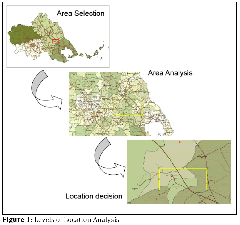
Figure 1: Levels of Location Analysis
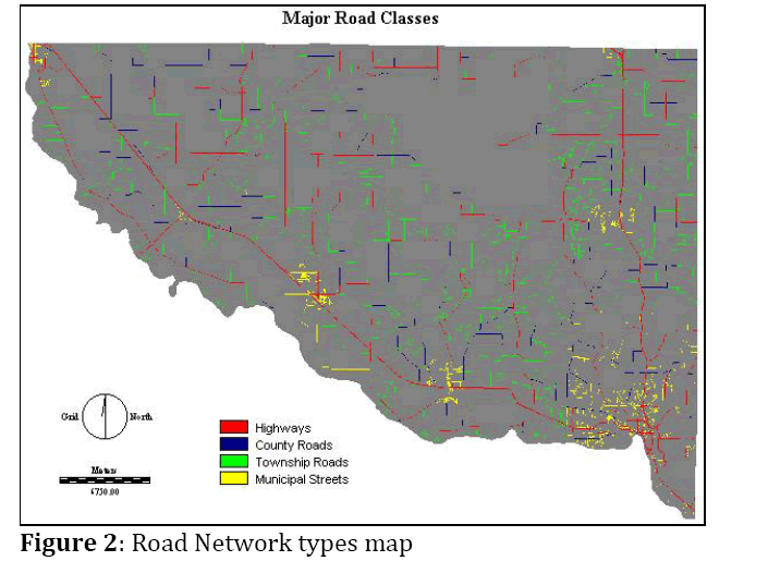
Figure 2: Road Network types map
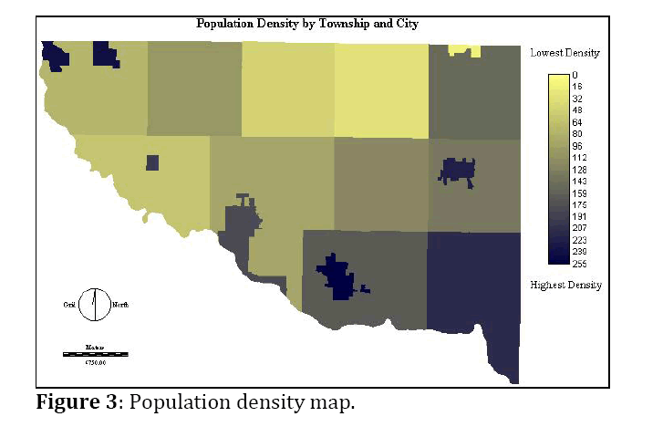
Figure 3: Population density map.
The decision of the final location is a complex issue and demands package solutions and also the participation of local inhabitants and authorities. One of the most common used algorithms to locate facilities centers is p?median. The initial purpose is to find the minimum number of locations, so that each demand point has one potential (solution) in a given maximum distance (or time). Following this, the suitable number of facilities is calculated so as to maximize the overall demand inside a maximum distance of services (or time), so that the total distance?length of movements of the population towards the facilities is the least possible (Haynes, 1984).
Conclusively the location of the business affects its development and viability. More specifically it has consequences in: a. the cost: different locations for a production centre or a centre for providing services represent a different cost for construction and functionality, b. its efficiency: the location of a centre reflects on how efficient the programs that demand its creation are, c. its use: the location of a centre reflects to the level of use from the area's citizens whose servicing for has been designed, and d. in other centres: the location of a centre reflects positively or negatively in cost, efficiency and use of other centres. (Haining, 1998)
Location of Medical Facilities
As for the location of medical services facilities, despite the new technologies (like telemedicine ? which facilitates the reaction to a distant event), their location continuous to be a distinctive advantage since immediate access and service is the objective target. Significant factors are still the nature of the situations a facility has to face as well as the displacement time both in cases of diagnosis and in cases of remedies, which is important and in various cases decisive. Parallel to the best location the best possible co?operation with specialized doctors and nursery personnel from the wider region is assured, an important functional parameter. The location of a general clinic – hospital unit acquires a greater value from the location of any other centre or department because the services provided are directly related to the time of displacement and the innovative ideas can be easily copied from competitors. So location, which guarantees a quick and easy access, is the competitive advantage. That conclusion is associated with the general interest reported for the matter and the existence of a capable number of relative studies in international and Greek bibliography. The most representatives and challenging ones are outlined below:
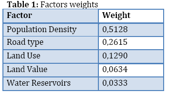
A) Location of a new Hospital in Minnesota: The aim of this study was to allocate the best area for a new hospital in Minnesota. According to this analysis, the selection area was determined by sociological, financial and environmental facts. As far as the methodological approach is concerned, initially the most important criteria were determined, based on which analysis maps were created. After a multiple criteria analysis was performed to exclude unsuitable areas and to calculate the weights of each factor affects the final decision. Factors that were used are: Inclination, land cover, road network accessibility, population density, land uses, land values and distance from water reservoirs.
The conclusions from the research focus on: a) the necessity for optimal location of hospital, b) the creation of a suitable methodological framework and c) the selection of the proper variables and the correspondingly weights, when they are inserted into the model. Table 1 that follows shows these weights:
B) Modelling population access to New Zealand public hospitals: In this case a method for estimating the geographical accessibility of public hospitals is presented. Cost path analysis was used to determine the minimum travel time and distance to the closest hospital via a road network. This analysis was applied using census districts in New Zealand allowing geographical access to be linked to local populations. Average time and distance statistics have been calculated for local populations by modeling the total travel of a population if everybody visited a hospital once. These types of statistics can be generated for different population groups and enable comparisons to be made between regions. This study has shown that the northern and southern parts of New Zealand have high average travel times to hospital services. (Brabyn & Skelly, 2002).
C) System Decision Support for Medical Services: In this application the role of GIS is presented and the model of spatial interaction HIPPS (Health Information for Purchaser Planning System) that was created with the aid of the University of Bradford and the local authorities of Airedale. Spatial Interaction models (or gravity models) are used for the prediction of demand, of the new services centers and for the estimation of consequences of environmental factors for each function. These models, depending on the problem under consideration, are based on a spatial pattern of the offer and the demand of a service. The specific model integrated the people’s satisfaction from the offered services by the medical centers. Personal data of the people were used, such as date of birth, kind of disease they suffered, treatment, location of residence, cost of treatment etc. The above study outlined that: a) spatial interaction models are powerful prediction tools for question of type “what if”. It is rather difficult to make them work efficiently on a globally scale, but instead they should be customized for local use, depending on each specific problem, b) these models depend on the stochastic behavior of the customer. This means the original hypotheses, which that between facilities with similar accessibility, the individual selects the most attractive one (the one with the best services) and correspondingly the closest one when the facility offers the same services. Finally, c) the input of more data (such as mortality rates, number of rooms, time spending in the facilities), improves the accuracy of the model. Additionally, the smaller the number of facilities that offer a specialized service, the better the prediction.
D) Hospitals accessibility: In this paper, the accessibility of hospitals in Ireland was examined. Spatial data in the form of hospital location and size, road network and demographic distribution of over 65’s were integrated in GIS Database. A weighted accessibility formula was applied to produce a measure of accessibility called a Spatial Accessibility Measure based on travel time, hospital size and population?weighting. This measure was then applied to produce three scenarios modelled on; a) the existing configuration of services, b) a partial roll?out and c) a full roll?out of the proposed changes The work provides a valuable and previously underdeveloped set of policy?informed spatial outcomes which can be adjusted if or when more beds are introduced into the Irish health care system in the next five to ten years. (Kalogirou & Folley, 2006)
E) Spatial accessibility of primary care: Finally a recent work facing the problem of spatial accessibility was presented by M. Guagliardo in 2004. As the author states: “ Recent advances in the field of health geography have greatly improved our understanding of the role played by geographic distribution of health services in population health maintenance. However, most of this knowledge has accrued for hospital and specialty services and services in rural areas. Much less is known about the effect of distance to and supply of primary care on primary care utilization, particularly in the U.S. For several reasons the shortage of information is particularly acute for urban areas, where the majority of people live.” Other issues are also addressed such as affordability of care, measures of accessibility. The research concludes that simple measures of distance are not sufficient for describing complex urban environment, and more factors should be taken under consideration and more “private” data from the patient, in order for the analysis to be accurate.
Conclusions
Overall, from the above studies, the need for an integrated decision support system arises, for the planning of a medical service system that combines best accessibility and services, depending on a robust methodological framework. Although the location of every business depends on many factors (objective and subjective) the use of an integrated methodological framework is needed, especially when locating medical facilities, because the consequences affect directly the inhabitants of a specific location.
From the up to date experience, two groups of criteria should be considered, about location of medical facilities: a) quantitative (these target the physical characteristics of places) and b) qualitative (these target the special weight of each service demanded). The analysis and process of the above data can be easily performed with the aid of GIS software that incorporates both geographical and descriptive characteristics and also can depict the results in high quality maps, tables and figures. However, in the increasingly information?intensive environment of tomorrow's health care, the role of GIS will have greater importance due to its abilities to integrate a wide range of data sources, from legacy systems to image data, and to make complex data more quickly and easily understood.
3682
References
- Brabyn, L.& Skelly, C. ‘Modeling population access to New Zealand public hospitals’, International Journal of Health Geographics 2002; 1 (3) 1‐9.
- Berman, B., & Evans, J.R. Retail management: a strategic approach, 2nd ed, New YorknMacmillan Publishing 1983.
- Clarke, I. ‘Deconstructing retail location decisions’, Working paper presented to the Second Recent Advances in Retailing & Services Science Conference, Broadbeach, Goldcoast, Australia, 1995nJuly; 11‐14.
- Danylkiw, K.& Doran, A. ‘Applying GIS to Find The Most Suitable Location For The Sherburne County Hospital’ 2002.
- Ghosh, A., McLafferty, S.L. Location Strategies for Retail and Service Firms, Lexington Books, Massachusetts1987.
- Guagliardo MF. Spatial accessibility of primary care: Concepts, methods and challenges. Int J Health Geogr 2004; 3(3):1‐ 13
- Haining, R. ‘Spatial statistics and the analysis of health data’, in Gatrell, A. & Löytönen, M., (Eds.) GIS and health (pp. 29–47) London: Taylor& Francis1998.
- Haynes K, & Fotheringham, A.S. Gravity and spatial interaction models, London: Sage 1984.
- Huxholid, W.E. An Introduction to Urban Geographic Information Systems, New York: Oxford, University Press 1991.
- Kalogirou, S. and Foley, R. Health, Place & Hanly: Modelling Accessibility to Hospitals in Ireland. Irish Geography 2006.